For many anglers, the Río Gallegos begins as a name.
It appears in conversations about Patagonia, in stories about sea-run brown trout, in dream-trip planning, and in the kind of fishing talk that turns a river into legend long before someone ever sees it in person. But once the idea of the trip becomes real, another question naturally follows:
What is the Río Gallegos actually like as a place?
That is where geography begins to matter.
For fly fishing anglers, understanding the geography of the Río Gallegos is not just about orienting yourself on a map. It is about understanding how the river is experienced, how different areas gain meaning, how names become part of angling culture, and why one section of the river can feel very different from another. On a destination this respected, the geography is not background. It is part of the fishing itself.
The Río Gallegos is one of Patagonia’s most admired sea-run brown trout rivers, and like all memorable rivers, it is not experienced as one uniform line of water. It is understood through stretches, known zones, surrounding estancias, named pools, changing moods, and the way anglers learn to connect place with possibility.
That is what makes its geography so important.
A famous river is never just one thing
When people first hear about the Río Gallegos, they often imagine a single legendary river with a single identity.
That idea is understandable, but incomplete.
What gives a river true character is not only its reputation as a whole, but the variety and specificity within it. The Río Gallegos may be united by its broad sea-run brown trout identity, but within that larger fame are areas, sections, and landmarks that help anglers make sense of it. These details matter because fly fishermen rarely experience a river as an abstract line. They experience it through the places where they stand, the water they cover, the names they remember, and the stretches that seem to gather meaning over time.
That is why geography matters so much here.
To understand the Río Gallegos, it helps to stop thinking of it only as a destination and begin thinking of it as a landscape with internal structure. That shift changes everything. It makes the river feel more real, more vivid, and more personal.
Why geography matters in fly fishing
Geography in fly fishing is not only physical.
It is emotional, practical, and cultural all at once.
Physically, the geography of a river shapes access, flow, surrounding terrain, and the overall setting of the day. Practically, it affects where anglers fish, how they move through the system, and what kind of experience a lodge can offer. Culturally, it creates the shared language that fishermen use when they talk about a river. Certain names gain weight. Certain areas become familiar even before a guest arrives. Over time, these names become part of the mythology and memory of the fishery.
The Río Gallegos is exactly that kind of river.
Its geography helps define how anglers imagine the destination before they arrive, and how they remember it long after they leave. A place name on the Río Gallegos is rarely just a label. It often carries a sense of atmosphere, a hint of history, and the promise of meaningful water.
For serious anglers, those things matter.
The river as a collection of meaningful places
One of the best ways to understand the Río Gallegos is to see it not as one generic body of water, but as a collection of meaningful places.
That does not mean it loses coherence. Quite the opposite. It means the river becomes more understandable. The larger identity remains strong, but it is expressed through recognizable areas, estancias, sections, pools, and surrounding landscapes. These pieces are what allow anglers to form a mental map of the fishery.
This matters because most traveling fishermen do not simply want to know that they are going to Patagonia.
They want to know what kind of Patagonia experience they are stepping into.
They want to understand what part of the river they are connected to.
They want to picture the surrounding land.
They want to know whether the place feels anonymous or rooted.
They want the geography to mean something.
On the Río Gallegos, it usually does.
Estancias as part of river geography
In many parts of Patagonia, estancias are more than neighboring properties.
They are part of how the river is understood.
For anglers, estancia names often become reference points that help define stretches of water and the broader identity of the fishery. A known estancia may give shape to the map, helping traveling fishermen understand where one section lies in relation to another. It can also become part of the river’s shared vocabulary, especially on a destination where visitors arrive from many countries and begin piecing together the landscape before ever setting foot on the bank.
The Río Gallegos has this kind of geography.
Certain estancia names become familiar because they help mark important zones within the wider river system. That does not mean the river belongs to a single narrative. It means that the angler’s understanding of place is built through real landmarks tied to the land itself.
This is one of the reasons location becomes such an important part of the lodge experience. A lodge is never just on the river. It is in relation to areas, names, and known sections that give it context.
Why named areas matter
Named areas matter because they make the river feel lived in.
A famous river can seem distant or abstract until its geography begins to take shape in the mind. Once anglers start hearing names tied to real water and real sections of land, the fishery becomes more tangible. The trip becomes easier to imagine. The destination starts to carry not only prestige, but personality.
This is especially true on the Río Gallegos.
An area like Laguna Colorada, for example, gives the river a stronger sense of identity. It allows anglers to think more specifically about where they are going and what kind of place they are entering. That kind of specificity is deeply valuable in destination fly fishing. It replaces broad fantasy with more meaningful anticipation.
And anticipation, after all, is part of the experience.
The best fishing trips often begin long before the first cast. They begin when a place starts to feel real in the imagination.
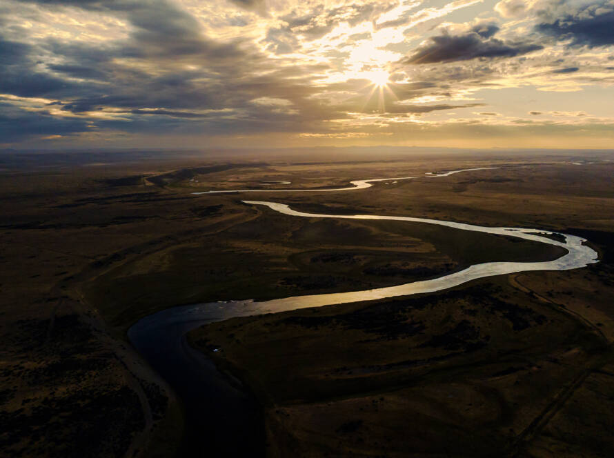
Reading the river beyond the map
A map can show lines, names, and general relationships.
But for anglers, understanding the geography of the Río Gallegos means reading beyond the map.
It means understanding that some places feel more open, more exposed, more iconic, or more rooted in the culture of the river. It means noticing how certain sections seem to carry more emotional weight in the stories anglers tell. It means realizing that geography is not only about location, but also about how a place is experienced.
A river becomes meaningful when physical form and lived experience begin to overlap.
On the Río Gallegos, that overlap is everywhere.
It is in the open sweep of the Patagonian steppe.
It is in the relationship between river and wind.
It is in the way a named area can transform broad curiosity into vivid expectation.
It is in the feeling that some stretches carry a stronger sense of identity than others.
This is why serious anglers tend to care about geography. They are not just gathering information. They are building a mental relationship with the river before they arrive.
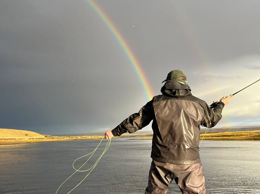
The importance of place in sea-run brown trout fishing
Sea-run brown trout rivers often inspire a different kind of attention.
There is something about migratory fish, large landscapes, and difficult water that makes place feel inseparable from the pursuit. Anglers do not usually travel to a destination like the Río Gallegos for convenience alone. They come because they are drawn to a specific kind of river identity, one that combines challenge, beauty, scale, and emotional power.
Geography is part of that identity.
It affects how the water is talked about, how the day unfolds, and how the trip is remembered. It turns the fishing from an activity into an experience shaped by context. That context matters more on a river like the Río Gallegos than on many easier or more generic destinations, because the geography itself becomes part of the attraction.
The fish may bring anglers here.
But the place is what often stays with them.
Karku and the geography of the Río Gallegos
For Karku, geography is not a secondary detail.
It is one of the lodge’s real strengths.
Karku is located in the Laguna Colorada area of the Río Gallegos, next to the well-known Estancia Las Buitreras zone, within one of Patagonia’s most meaningful sea-run brown trout settings. That location connects the lodge to a part of the river that already carries strong identity for many anglers. It also gives guests a clearer sense of the surrounding landscape and the broader geography they are stepping into.
That matters because a lodge feels different when it is rooted in a recognizable part of the river.
It feels more grounded.
It feels more connected.
It feels more memorable.
For anglers researching Patagonia, that kind of location helps transform Karku from a name on a website into a place that belongs to the geography of the Río Gallegos in a clear and tangible way.
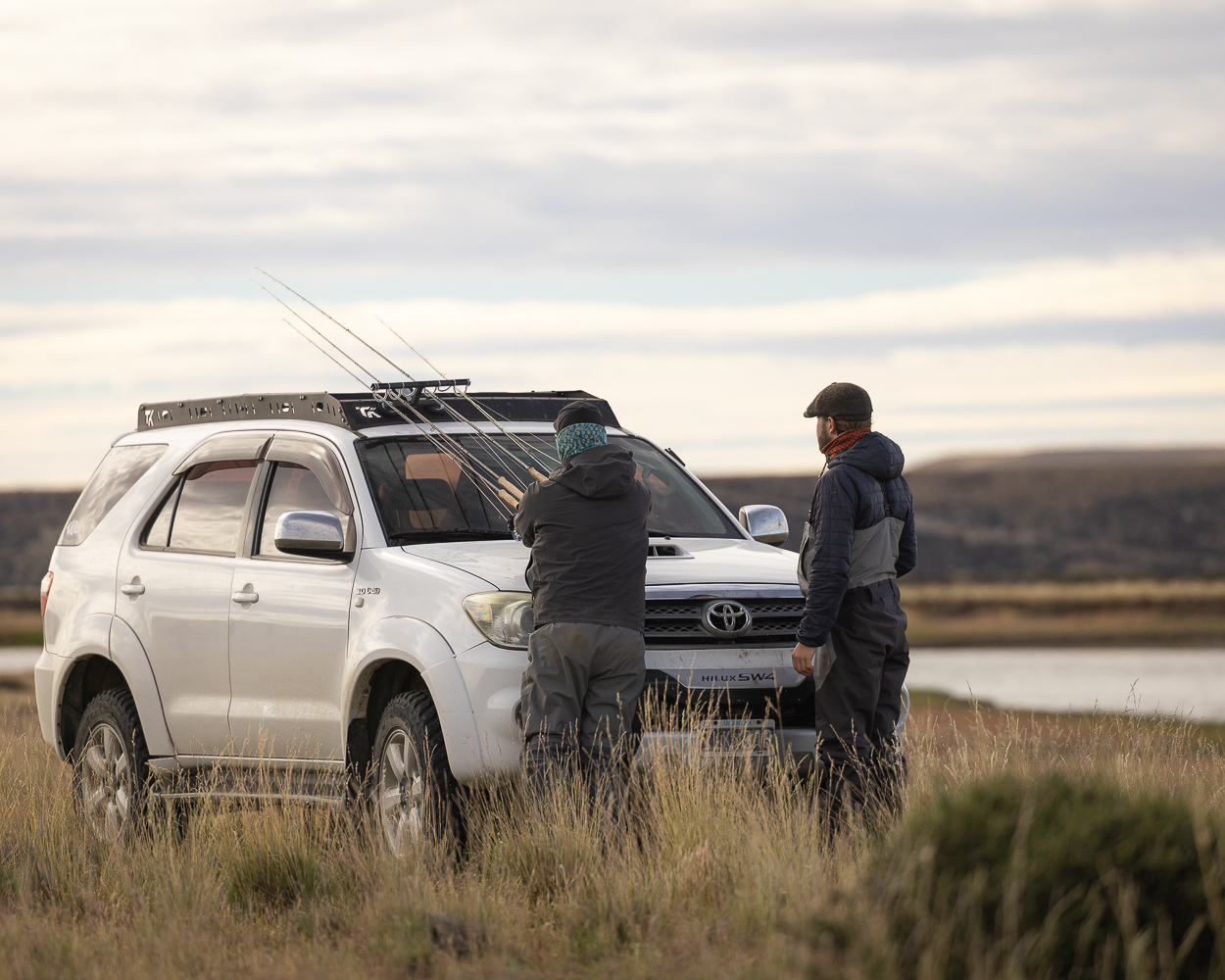
Why serious anglers pay attention to this
The more experienced the angler, the more likely they are to care about river geography.
They want to know whether a lodge feels connected to meaningful water.
They want to understand the section of river they will be fishing.
They want a destination that sounds rooted in place rather than generically marketed.
They want names, landmarks, and a real sense of setting.
These are not minor concerns.
They are part of what separates casual travel from serious destination angling.
On the Río Gallegos, geography becomes one of the ways an angler begins to trust the experience. It creates substance. It gives shape to expectation. It makes the destination feel worth the journey before the journey even begins.
From reputation to reality
The Río Gallegos has no shortage of reputation.
It is known among fly fishing anglers around the world as a river of sea-run brown trout, strong wind, memorable water, and hard-earned moments. But reputation alone is never enough. To truly understand a river, anglers need a clearer sense of its inner shape. They need to understand how the geography works, how places are named, and how different parts of the landscape contribute to the larger experience.
That is where the river becomes real.
The moment an angler starts to understand areas like Laguna Colorada, recognized zones along the river, and the way estancias and sections help define the fishery, the Río Gallegos stops being only an idea.
It becomes a place.
And that is when the trip begins to feel truly possible.
Final thoughts
Understanding the geography of the Río Gallegos is about far more than learning names on a map.
It is about understanding how a famous sea-run brown trout river is actually experienced. It is about the stretches, estancias, named areas, and surrounding landscapes that give the river identity. It is about seeing Patagonia not as a distant dream, but as a real place with structure, mood, and meaning for the anglers who travel there.
That is why geography matters so much on the Río Gallegos.
It gives shape to the fishery.
It gives context to the experience.
It gives memory a place to land.
For anglers planning a Patagonia trip, and for those considering where to stay on this legendary river, that understanding can make all the difference.
If you want to experience the Río Gallegos from a lodge deeply connected to its landscape and character, discover Karku Fly Fishing Lodge, explore its setting in the Laguna Colorada area, and begin planning a journey through one of Patagonia’s most memorable fly fishing environments.